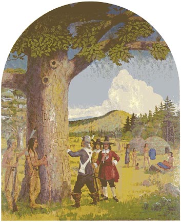
Murals: Stamford scenes from yesteryear
 Setting
the boundaries
About 1655
The
land on which Stamford was settled was purchased from the Indians in July
of
1640 by Capt. Nathaniel Turner, agent for the New Haven Colony. He paid 12
English coats, 12 “howes”, 12 hatchets, 12 glasses, 12 knives, 4 kettles and 4 fathoms
of white wampum. During November of that year, the land was sold by the New
Haven Colony to our first settlers for the equivalent of 33 pounds in terms
of “corne”.
In 1655 the boundaries of Stamford
were defined for the first time. The sons of the Indian Sagamores who had made
the first treaty were disgruntled with the original terms, and in order to dispel
this dissatisfaction, a new treaty was drawn.
The boundaries
were described as “from
the town plot of Stamford north about 16 miles and there we marked a white oak
tree with S. T. and going toward the Mill River side we marked another white
oak tree with S. T. and from that tree west we were to run four miles... and
from the first marked tree to run four miles Eastward”.
Thus, a rectangular plot was defined,
16 miles almost due northwest and 8 miles in breadth. This tract took in a goodly
portion of the present towns of Greenwich, Bedford, Poundridge and New Canaan,
and a good part of Darien.
Under the second treaty the Puritans
were to have an additional two miles to the northwest for the purpose of grazing
cattle. The Indians in the back ground of this mural are counting the additional
coats given in the settlement of the second treaty. The exact boundary line
is not known. The hills in the background were painted from hills lying just
to the north of Bedford, New York. The initials S. T. denote Stamford, and as
here used, its northern boundary.


Preface
Spring
of 1642: Settlers observe the Sabbath
About 1655: Setting the boundaries
October 1789: Townfolk greet George Washington
About 1842: Canal to the sound
Christmas Day 1848: First train to Stamford
Atlantic Street 1905
Stanley J. Rowland: About the artist
Image © The Stamford Historical Society

